Ground-Water Suitability Modeling & Management for Solar-Powered Irrigation using QGIS based MCDA approach.
Published on July 1, 2026

In this article, I will take you through the steps of generating a suitability map based on GIS Multi-criteria decision analysis (GIS-MCDA). Information and communication technology, which has been incorporated and provided in the Geographic Information System (GIS), is valuable and effective geospatial information for the decision-makers in improving their decisions in planning and development.
In this study, I will focus on suitability modeling of Solar-Powered Irrigation Systems (SPIS) in Bangladesh using 5 parameters, such as 1. Groundwater (GW) availability, 2. Solar Irradiance, 3. Slope, 4. Salinity, 5. Landuse (Agricultural cropland). The methodological framework for GIS-based MCDA consists of mainly 3 steps: A. Constraint Formulation, B. Reclassification Criteria, C. Weighting Factor.
A. Constraint Formulation
The criteria for excluding the unsuitable areas for solar pump irrigation has been presented in Table 1. Since the SPIS mapping is focused on providing solar-based groundwater extraction for agriculture. Therefore, we ignored the landcover other than agricultural cropland. We excluded the regions with solar irradiation lower than 1300 kWh m-2 y-1 based on extensive literature reviews. Considering our solar pump specification, the groundwater table depth of 0–7m and 7.1–25m were only included for further analysis, others were simply ignored. The slope greater than 8% is not suitable for gravitational irrigation. Furthermore, the aquifer productivity lower than 0.1 liters per second is ignored.
B. Reclassification Criteria
The reclassification criteria were set using the r. reclass plugin within Grass GIS. The plugin reclassifies the raster map based on category values. These categorical values are obtained from available literature reviews and experts knowledge. We reclassified the input raster maps for several of our available datasets, such as:
1. Ground Water Availability
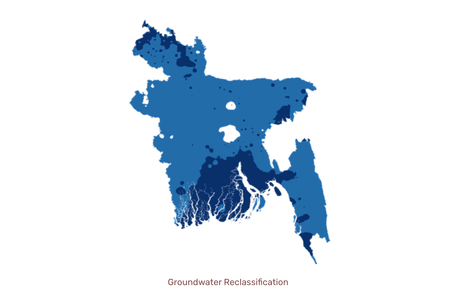
The criteria for the reclassification of groundwater was based on the specification of the available pumps, i.e. two categories with pumping depth up to 7m and other with 25m. During reclassification on a scale of (1–5), the highest suitability was provided for 0–7m with a suitability rank of 5, whereas 7.1–25 m was given moderate suitability with a rank of 4. All other depths were ignored for our analysis. The figure below demonstrates the GW reclassification, with dark blue areas as highly suitable regions, lighter blue as moderately suitable and null regions(white) as our constraints.
2. Solar Irradiance
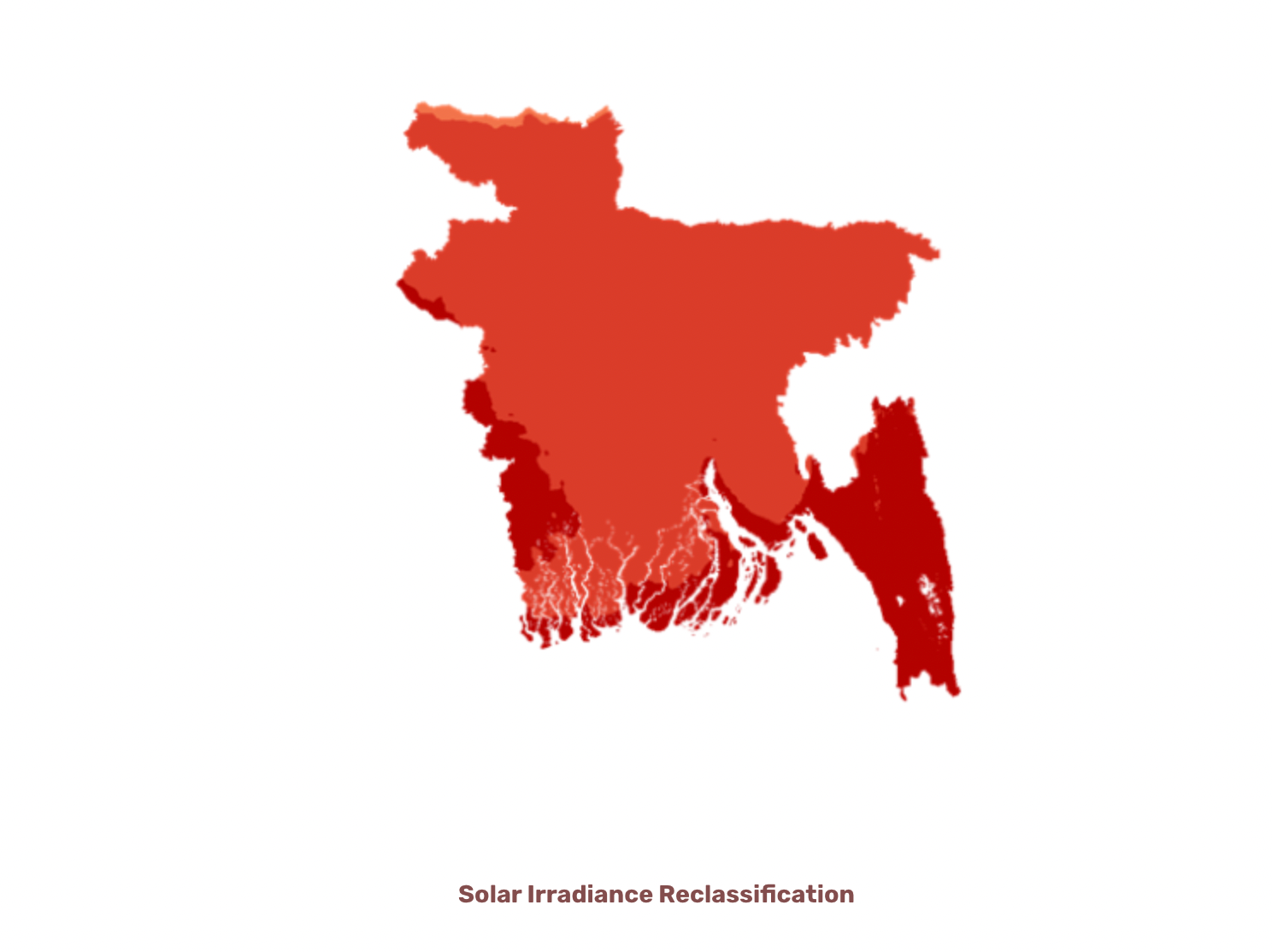
The solar irradiance in terms of Global Horizontal Irradiation (GHI) was acquired using Global Solar Atlas at a spatial resolution of 1km. First, we remove all irradiance values less than 1300 kWh m-2 y-1 which is a constraint in our case. Afterward, we reclassify the irradiance on a scale of 1–5 based on the criteria below:
1. 1700–1784 = 5 High
2. 1600–1700 = 4 Moderate
3. 1594–1600 = 3 Less Suitable
4. Everything else = * Constraint
3. Slope
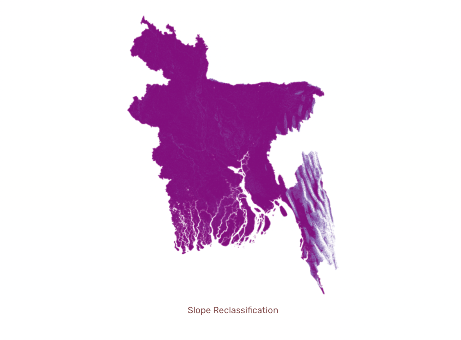
The slope values were reclassified based on the criteria below:
1. 0% — 2% = 5 (score) Highly Suitable
2. 2% — 4% = 4 (score) Moderately Suitable
3. 4% — 8% = 3 (score) Less Suitable
4. 8% = Constraint.
4. Salinity
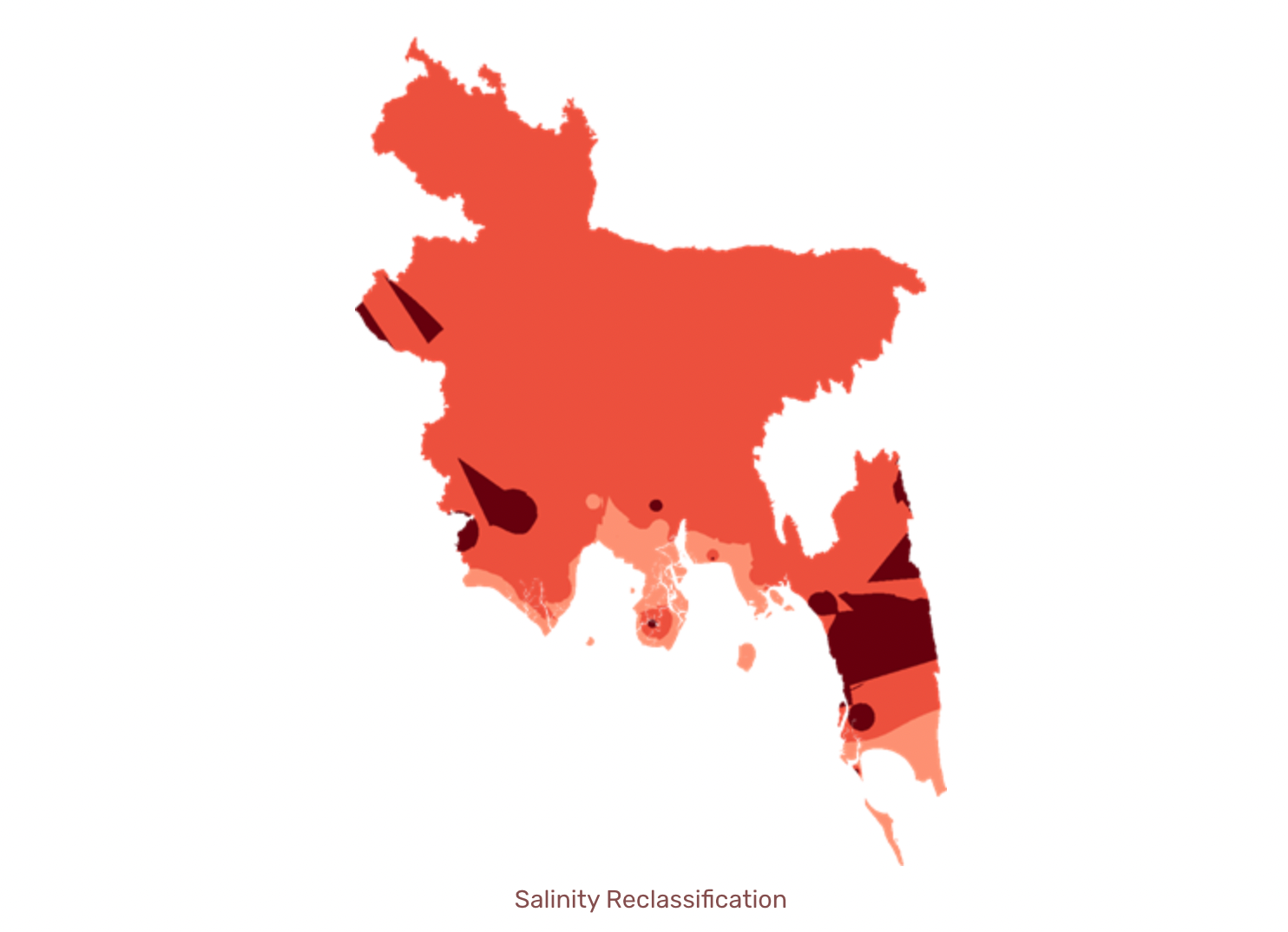
Salinity is an important factor as it has a huge effect on agricultural crops. The presence of salt in the soil solution reduces the ability of the plant to take up water, and this leads to reductions in the growth rate. Therefore, we plan to remove the salinity values greater than 2. The values lying within our threshold were reclassified on a scale of 1–5, as:
1. 0 -1 = 5 (Highly Suitable)
2. 1–2 = 4 (Moderately Suitable)
3. Everything else = NULL
5. Landcover (Agricultural cropland)
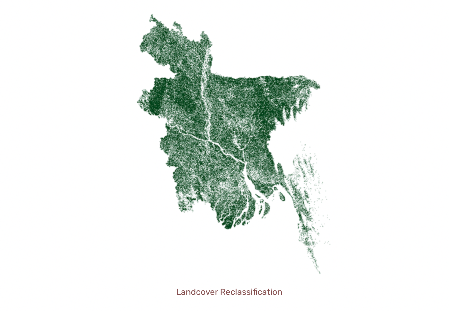
As this research is focused on mapping the feasibility of SPIS only for specific Landcover type, i.e. agricultural cropland, we will keep all other land cover types except agricultural cropland as our constraint factor. The green areas in Figure 6 represent agricultural cropland, whereas the regions in white represent the constraints. Furthermore, we reclassified each dataset to a common scale (0-5), where 5 represents higher suitability.
C. Weighting Factors & Suitability Mapping
Several layers and maps were developed and reclassified as per criteria, and a pairwise matrix was applied to the reclassified maps similar to Saaty 1977. Besides this, the weighting factors were determined based on expert knowledge and then tuned to various scenarios/models. As discussed earlier, the mapping will be dynamic to allow the development of different scenarios. Table 3 represents the weighting factors developed for pairwise matrix comparison across two different scenarios. Furthermore, we will develop several other scenarios for enriched understanding the effect of weight on the final suitability model.
Table 3. Weighting factors developed with two different scenarios for pairwise comparison
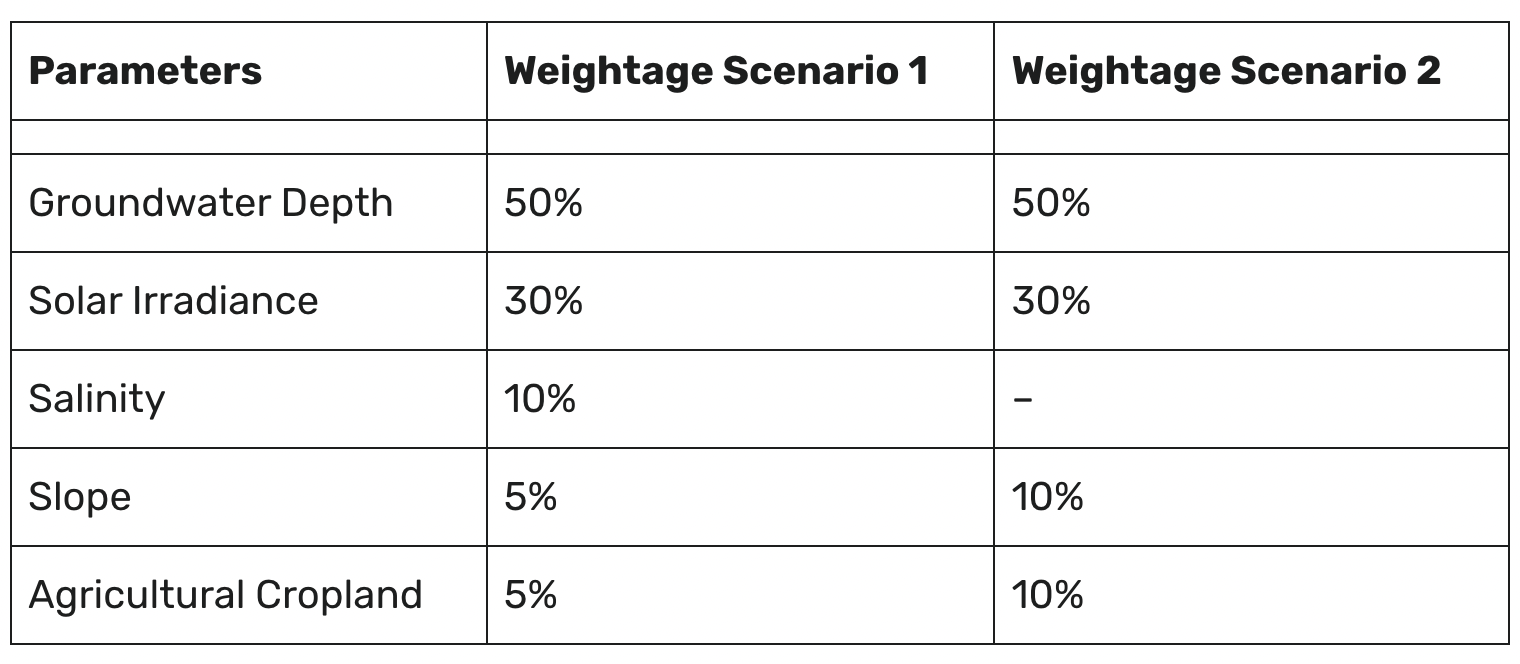
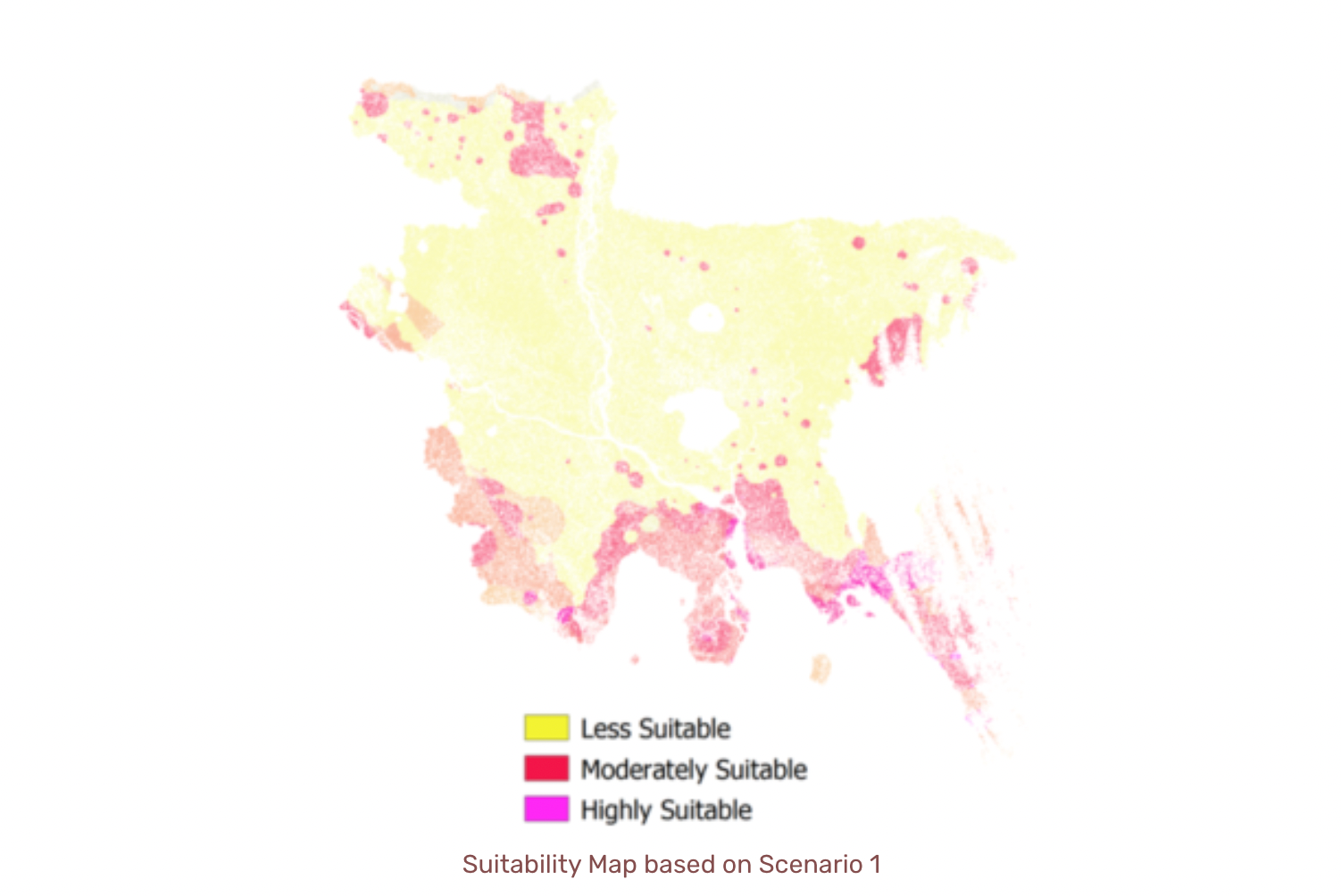
The final suitability map based on scenario 1 has been presented above. Scenario 1 takes into account all 5 parameters, where the highest priority has been set for Groundwater Depth (50%), Solar Irradiance (30%) and Salinity (10%). The least priority was set for Slope and Agricultural cropland with both having the weight of 5%. The highest priority was given for GW Depth and Solar Irradiance because these parameters have a greater influence over determining the feasibility of SPIS which was in accordance to the literature published by IWMI (Schmitter et al. 2018).
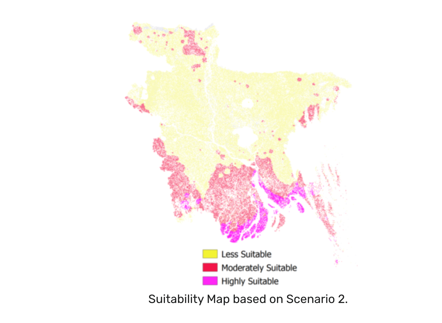
Likewise, the final suitability map based on scenario 2 has been presented in the figure above. Scenario 2 removes the salinity parameter from the analysis which results in increased suitable areas around the coastal regions of Bangladesh. However, this approach is not suitable considering the fact that the presence of salinity in groundwater reduces the growth rate and has an adverse effect on agricultural production. Therefore, we will implement zero tolerance in the salinity parameter by keeping it as a constraint during our analysis.
Finally, in the next iteration, we will consider several other scenarios while analyzing the feasibility of SPIS mapping. We will set the criteria through discussions with experts. The plan is to develop a dynamic mapping system whose parameters and threshold values can be customized/ adjusted to reflect changes in policy or natural changes such as a change in water availability or landuse.

Suman Ghimire
CEO/Chairman
Suman writes about the precision Agriculture technology on the topic of "Enhanced Vision for farmers in Nepal".